The United Nations has backed a non-binding resolution encouraging countries, schools and tech companies to use maps that more accurately reflect Africa’s true size.
On 4 September, the United Nations General Assembly adopted a resolution called “Correct the Map,” led by the West African nation Togo and supported by the African Union. It passed 164- 1, with six countries abstaining.
The resolution encourages governments, schools, international organizations, and technology companies to use maps that more accurately represent the relative sizes of continents, particularly when comparing areas.
So why is everyone suddenly talking about something that was technically a geography problem for centuries?
Wait, But What Was Wrong With the Old Map?
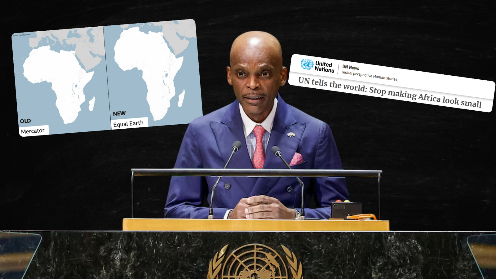
The map most of us grew up seeing is called the Mercator projection. Flemish geographer Gerardus Mercator created it in 1569, primarily for sailors. It was extremely useful because it preserved directions, making it easier to navigate across oceans.
The problem is that it does not preserve the actual size of countries and continents.
The further you move away from the Equator, the more land gets visually stretched. That means places such as Greenland, Canada, Russia, and northern Europe look much larger than they actually are compared with regions closer to the Equator.
The most famous example is Greenland and Africa. On a typical Mercator map, Greenland can look almost as large as Africa.
In reality, Africa is around 14 times larger.
And that is where the debate goes beyond geography. African governments and campaigners argue that when generations of people repeatedly see Africa represented as much smaller than it really is, the map can subconsciously shape how they understand the continent’s importance, population, resources, and economic potential.
In other words, the argument is not that Mercator was a “bad map.” It was actually very good at the job it was created for.
The argument is that we kept using a map designed for sailors as though it were the perfect picture of the entire planet.
What Did the Countries Say and Vote?
Togo led the campaign on behalf of the African Group, with support from the African Union. The resolution was adopted with 164 countries voting in favor.
Egypt was among them.
The six countries that abstained were Estonia, Georgia, Lithuania, Moldova, Serbia and Ukraine.
And then there was the United States.
Of course, the U.S. was the only country to vote against it.
The American representative argued that the General Assembly was ‘wasting its time debating a 16th-century map’ rather than focusing on issues such as ‘international peace and prosperity ’. The U.S. also objected to the resolution’s language regarding concepts such as “cognitive justice” and reparations.
France, meanwhile, went in the opposite direction. French Foreign Minister Jean-Noël Barrot said France planned to move away from the Mercator projection for its world maps, arguing that correcting a distorted representation is already a step toward a more truthful one.
So What’s the Difference Between the New and Old Map?
The UN is promoting the Equal Earth projection, developed in 2018.
Unlike Mercator, Equal Earth is an equal-area projection, meaning countries and continents are represented in proportion to their actual surface areas.
Put Africa next to Europe, and the difference becomes immediately obvious. Africa looks much larger because it actually is.
But there is an important catch: there is no such thing as a completely perfect flat map of Earth.
The planet is a sphere, while your screen, textbook, or classroom wall is flat. You cannot flatten a globe without distorting something.
Mercator prioritizes direction. Equal Earth prioritizes area. Other projections prioritize different combinations of shape, distance, or appearance.
So the UN is not saying that every Mercator map ever made is suddenly “wrong.” It says that when the purpose of a map is to compare the sizes of regions, an equal-area projection makes more sense.
When Is This Taking Effect?
This is probably the biggest misunderstanding around the story.
Nothing is changing in the short term.
The UN resolution is non-binding. It does not legally require Google, Apple, schools, or governments to throw away their Mercator maps.
Instead, it encourages governments, educational institutions, international organizations, and technology companies to gradually use equal-area projections such as Equal Earth, particularly when relative size matters.
So there is no official “new map day” when the entire world abruptly switches overnight.
The bigger significance is symbolic.
For Africa, this is part of a much longer conversation about how the continent has been represented internationally. The African Union had already endorsed Equal Earth earlier this year, and the UN vote takes that campaign to a much larger global stage.